The Dane Valley Way
The Dane Valley Way
Follow the Dane Valley Way from the Peak District to Cheshire, tracing the River Dane through wooded valleys, historic mill settlements, rugged walking country and changing landscapes.
The Dane Valley Way follows one of the quieter rivers of northern England, tracing the course of the River Dane from its upland beginnings near the high ground of Axe Edge Moor through the folds of the Peak District fringe, across the sandstone and pasture country of Cheshire, and eventually towards the broad lowlands where the river joins the Weaver. What appears on a map as a simple long-distance footpath soon reveals itself as something more layered, for the route passes through landscapes shaped not only by geology and weather but by centuries of farming, industry, transport and settlement, all connected by the persistent presence of moving water.
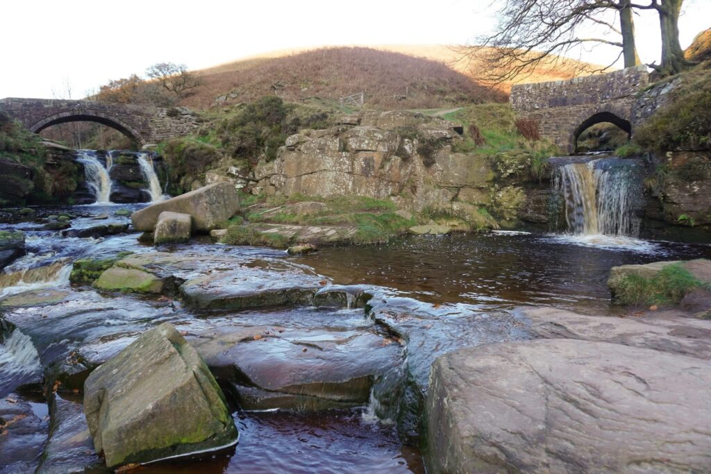
In its upper reaches, around places such as Three Shires Head, Gradbach and Wincle, the Dane feels very much a hill river. Here the valley narrows between steep slopes and wooded cloughs, with gritstone edges and rough pasture creating a landscape that can feel surprisingly remote despite its proximity to larger towns. The river itself moves quickly through rocky channels and shaded pools, while paths climb and descend more than many visitors expect, following contours established long before leisure walking became fashionable. Packhorse routes once crossed these valleys carrying salt, coal, lead and agricultural produce between communities that depended on difficult journeys through country that could be unforgiving in poor weather.
Around Gradbach the landscape carries some of the most distinctive atmosphere on the entire route. The wooded valley below the old mill settlement feels enclosed and ancient, with moss-covered stonework, steep-sided slopes and the sound of water accompanying the walker for long stretches. Gradbach Mill itself reflects a pattern seen repeatedly along the Dane and its tributaries, where flowing water provided the power necessary for rural industry. Such mills were once part of a wider economic system that connected remote valleys to markets far beyond the surrounding hills, and although much of that industrial activity has vanished, the logic that created these settlements remains readable in the landscape.
Further downstream, near Wincle, the valley begins to open slightly while retaining much of its rugged character. The river marks boundaries, feeds pasture and shapes routes through the countryside, while villages occupy positions that balance access to water with protection from flooding. Looking across the fields and wooded banks, it becomes clear that the apparent tranquillity of the modern landscape is the product of long periods of labour. Dry stone walls, field divisions, bridges, lanes and riverside crossings all represent generations of practical adaptation to terrain that was never entirely easy to work.
The ecological richness of the Dane Valley is equally important to its character. The combination of flowing water, woodland, rough grassland and agricultural land creates a corridor supporting a wide variety of wildlife. In early summer the riverbanks are crowded with growth, insects move through the sheltered margins, and birds use the wooded edges as both feeding and nesting habitat. The river itself acts as a connecting thread through the landscape, linking habitats in much the same way that it once linked settlements and industries.
As the Dane Valley Way continues north-westwards, the country gradually softens. The dramatic upland scenery gives way to broader farmland and gentler gradients, yet the same relationship between water, movement and settlement remains visible. Throughout its length the route demonstrates how a river quietly organises human activity, influencing where people build, travel, work and gather.
What lingers after walking the Dane Valley Way is not a single landmark or viewpoint but a growing awareness of continuity. The river still performs the work it has always done, carving channels, supporting wildlife and shaping the landscape, while walkers, farmers, villagers and visitors continue to move through a valley whose older purposes have not entirely disappeared. The path offers a journey through scenery, certainly, but also through the long relationship between water and people that remains written into the ground itself.
Contact
Buxton
SK17 9DH
Reasons To Visit
Walk beside one of northern England’s most overlooked rivers, discovering woodland valleys, historic mill sites, upland scenery, rich wildlife and landscapes shaped by centuries of water, labour and travel.
Close By - Worth Your Time
Best Local Cafe
Best Local Pub
The Knot Inn - Rushton Spencer
Local Accommodation